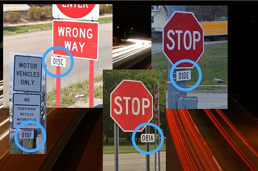
Explained: Understanding Michigan’s Expressway Ramp Codes
Drive any expressway in Michigan and there are tiny white rectangular signs with a code at every entrance and off ramp.
Just what do these codes mean? There's a sometimes simple, sometimes complex system.
Basically these are inventory markers. They are a number followed by a letter. The number represents the entire interchange while the letters represents the individual ramps. Say, I-94 meets M-52 in Chelsea. The interchange is 003 and the ramp from eastbound I-94 to M-52 is ramp A so that ramp is 003A. The ramp from M-52 to I-94 east is 003B and so on to 003D. If the interchange is more complex the letters could get as high as F-G-H if there are many ramps.
That's the relatively simple part of the ramp inventory system. The more complex part is the interchange number. What determines that is either the actual mileage on the highway or sequentially in each county. Confused? Let's try this with I-94.
Mileage numbers generally count up west to east and south to north so in our I-94 example the very first exit in Michigan is at New Buffalo. It's exit 1 and interchange 001. Next is Exit 4 at Union Pier and interchange 004. Near the state lines and at the beginning of highways the interchange numbers follow the mileage of the highway.
But...and it's a big ol' but, that system changes with higher mileage routes. In our Chelsea example above, the M-52 exit is the 3rd exit on I-94 in Washtenaw County.
READ MORE: Myth Debunked -The M on State Highway Signs Is Not for the University of Michigan
I-94 uses sequential interchange numbers through Berrien-Van Buren-Kalamazoo-Calhoun counties with the final exit in Calhoun County, Exit 121 at Albion as interchange 121. But the first exit in Jackson County, Exit 124 is interchange 001. The first interchange in Washtenaw County is also 001. But the first interchange in Wayne County, Exit 190 is back to interchange 190 matching the mileage.
Huh?
Say you have a rural county like Cass in southwest Michigan that has only one expressway interchange in the entire county where US 12 meets M-60 near Niles. That gets an 001.
But elsewhere near Niles in Berrien County, an interchange where US 12 met M-51 was interchange 70 which has nothing to do with mileage on either highway or sequentially in the county. With another expressway in the Niles area, US-31 which has just entered the state from Indiana, the first exit on that road, Exit 3 is interchange 80.
Even more thoroughly confused? You should be. It's a really complex system that seemingly changes at random.
These tiny reference markers that are likely only used by MDOT and police agencies ether are sequential by highway mileage or sequential by number of exits in the county or seemingly assigned at random. So though you won't likely ever need to use them, you may just now notice them and wonder just why they have the numbers they have.
50 of Michigan's "Must-Drive" Roads
More From 100.5 FM The River